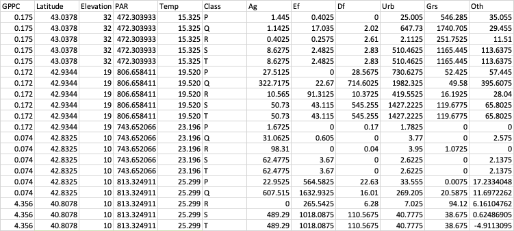
I have a dataset which contains areas covered by different landuse variables such as agriculture, forest, grassland etc for different spatial scales. The spatial scales that I have used are
- 30 m riparian scale = P
- 15 km riparian scale = Q
- 30 km riparian scale = R
- 30 km ring scale = S
- Whole watershed = T
The landuse variables are : Ag, For, Urb, Grs and Oth which refers to agriculture, forest, urban, grassland and others respectively. PAR, Temp and Elevation are other variables affecting productivity. I want to know
- what kind of landuse classification is the best to understand factors affecting productivity in rivers
- which landuse variable affects productivity in which spatial scale
The actual dataset has 102 observations with 30 variables. I am currently using "glmulti" package in R for automated variable selection. The program is still running because I have 2^n i.e. 2^30 models to run.
Currently the best model is something like this:
GPPC ~ 1 + Temp + PFor + QAg + QFor + QUrb + RAg + RFor + RGrs + RUrb + ROth
But, rather than this, I would like the variable selection to include each of the landuse variable only once, for example,
GPPC ~ 1 + Temp + PAg + RFor + RUrb + SGrs + SOth
Arranging my data like this
Is there any way to perform automated analysis and get results like this?
I thought of arranging my data like this.
But then I couldn't incorporate the "Class" i.e. spatial scale in the model.
Note: I have already used MuMin package and used dredge function but it took a very long time to process it. I could also select few variables using PCA but due to the nature of my analysis, I would like to use all the variables in a single model.


